


MILWAUKEE — For personal injury lawyers, they deal with people during some of the most traumatic experiences of their lives.
“I have a prior client who is quadriplegic,” Mark Mingo said. “Another client lost his leg. An existing client called me last night. She’s not recovering from her injuries. She’s getting worse.”
These are just three examples of the dozens of cases Mingo sees annually at his law offices, Mingo & Yankala. In the last three years, the business has skyrocketed.
Watch | Map: Wisconsin's deadliest roads in Milwaukee (courtesy 1POINT21 Interactive / Mingo & Yankala)
“Since the pandemic, we saw an increase in serious auto accidents,” Mingo said. “Which really didn’t make sense because in 2020, people weren’t driving as much and there weren’t as many people on the road.”
As more clients came in, Mingo was perplexed.
“We are a personal injury law firm, but we don’t sit here hoping people are involved in motor vehicle accidents,” Mingo said. “We’re here to help people who are injured.”
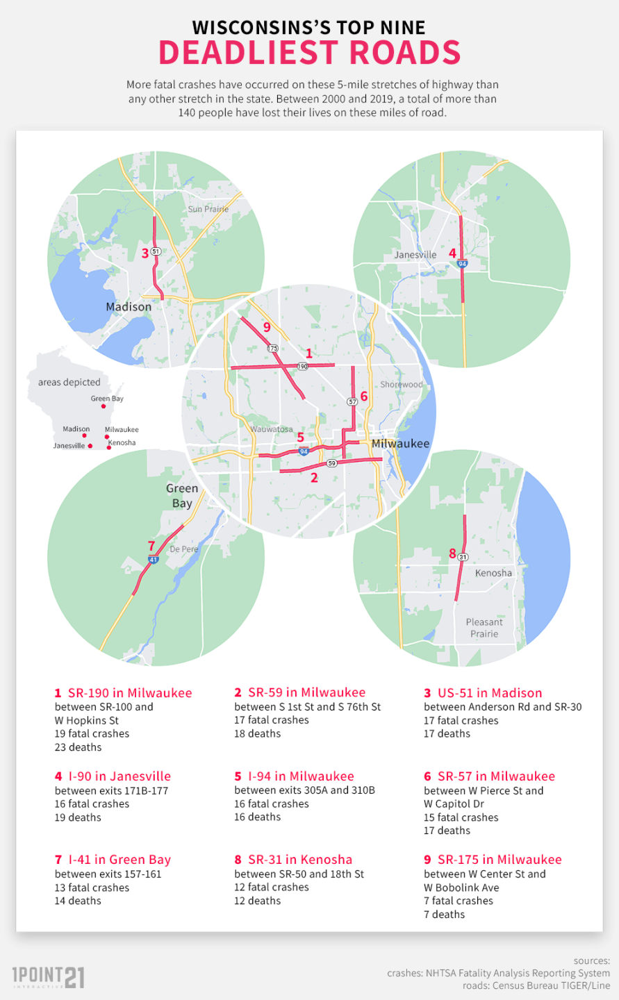
It’s why the law firm commissioned a study by San Diego-based 1POINT21 Interactive to look at the deadliest roads for drivers in the state. The study looked at all deadly crashes across the state from 2000 to 2019, naming nine roads as the deadliest in the state.
“We were really very surprised at what we found,” Mingo said. “I was surprised at the number [of deaths] and that there were five locations in Milwaukee where we have the deadliest motor vehicle accidents and the greatest number of fatalities.”
Mingo says 2020 saw the greatest increase in deadly crashes since 2005.
The roads on the list are a list of usual suspects. Capitol Drive, National Avenue, State Road 57, which includes portions of Green Bay and 27th Street, and I-94. The study looked at five-mile stretches of roads across the state.
“These are five-mile stretches of road so it’s a much, much smaller, very minute portion of the state’s road network that we’re talking about,” Brian Beltz with 1POINT21 Interactive said. “We analyzed 20 years of fatal crash data from NHTSA to try to find areas where fatal crashes accumulate. Some agencies or companies do this kind of thing, counting the number of collisions on an entire stretch of road. Even if it’s 200 or 300 miles, they’ll call it the deadliest road. I don’t think that’s very accurate. We wanted to find something a little more useful for people in their daily commutes and their daily lives.”
In total, the study shows 143 deaths across the nine identified corridors from 2000 to 2019. Milwaukee accounts for 81 of those deaths; 56.6 percent of the total.
“The goal of this is to identify those areas so people can be aware of them,” Beltz said. “They can make changes to their driving habits.”
“This can help point at locations where improvements should be made,” Robert Schneider, Urban Planning Professor at UW-Milwaukee said. “Taking a look where the most fatalities are shows there is a lot of work to be done.”
Schneider has worked in urban planning for over 20 years, working on dozens of studies around traffic. He says a study like this from 1POINT21 Interactive is a step in the right direction towards increasing safety for everyone. But he has concerns over how valuable the data can be toward achieving the goal of zero traffic related deaths.
“If we look at crashes between the year 2000 and 2019, we aren’t really representing the risk that is out there today,” Schneider said.
Pulling up the map of deadliest roads, Schneider pointed to several that have seen traffic calming measures implemented in the last 5 years or so.
“Highway 51 on the east side of Madison has had improvements,” Schneider said. “I-94 has had improvements made. Parts of Capitol Drive have also undergone reconstruction and redesign.”
It’s a hard balance to strike, Schneider says. Studies need enough data to draw conclusions, but also timely data.
One of the recent studies he co-authored identified the 60 deadliest roads for pedestrians across the country. The team looked at 1,000 meter stretches of roadway with at least six pedestrian deaths. Additionally, Schneider says their study, as is common in most traffic safety studies, looked at two eight-year periods to get a better idea of the impact of a specific area.
“If you don’t have enough years of crash data, you don’t see the patterns across the state or whatever jurisdiction you’re looking at,” Schneider said. “You need a long enough time to observe fatalities and injuries happening, but you don’t want it to be too long for not representing the system that does exist today. That’s something you’re trying to balance. More data is almost always better, but you have to realize, more change occurs over time.”
Schneider doesn’t discount what this study represents but thinks there are areas to improve upon, including breakdowns for the type of transportation users; pedestrians, bicyclists, motorists, etc. Additionally, other factors like time of day or type of roadways.
“There are some other breakdowns that are useful, but this is a good start,” Schneider said. “It’s important to do in the first place, looking at 20 years of fatality data to see where the highest concentrations of people being killed on Wisconsin’s roadways are. If we see there are fatalities occurring anywhere on the system, we want to reduce and eliminate the risk that’s there for any fatalities. When we see high concentrations in particular places, we know there is something we should do.”
Still, Mingo feels this is a good representation of the risk on Wisconsin roads.
“Absolutely,” Mingo said. “This isn’t an anomaly or isolated to Milwaukee or Wisconsin as a whole. It’s something we’re seeing nationwide. If we can help alleviate that number, whether it’s by one or two crashes or something greater than that, this was a great success.”
While the study highlights the deadliest corridors in the state, it also shows all the roads have one thing in common. They’re all maintained by the State Department of Transportation, not the individual municipalities the roads run through. Schneider says this could be attributed to volume since these roads have higher numbers of vehicles traveling on them daily.
WisDOT was not available for an interview on this study but provided this statement:
“The Wisconsin Department of Transportation is not able to comment on the conclusions of this external study, however, the state is committed to lowering the risk of traffic injuries and deaths on Wisconsin roads. WisDOT regularly reviews our own data to find solutions to engineering factors and driver behaviors that contribute to crashes.
WisDOT understands the importance of collaboration with all levels of government and community stakeholders and we share the common goal of improving safety on our streets. WisDOT relies on a combination of strategies to address challenges, including roadway improvement, traffic enforcement, and public education. We are working together with city leaders to approve rapid implementation pilot projects and to continue critical law enforcement partnerships in the city.”
Because these roads are maintained by the state, cities like Milwaukee will need approval from DOT to make any infrastructure changes to make improvements. If city officials need any help, Mingo is glad to volunteer the results of the study.
“I invite the mayor to take a look at it,” Mingo said. “Certainly, he’s not going to be responsible for a lot of the state roadways, but he can work with the state.”

